The Unique Maps Co.
Old Map of Olympia, Washington by USGS, 1959 – Tumwater, Budd Inlet & Capitol Lake
Old Map of Olympia, Washington by USGS, 1959 – Tumwater, Budd Inlet & Capitol Lake
Couldn't load pickup availability
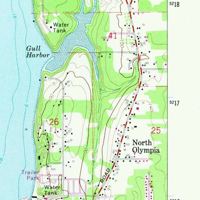
Published in 1981 using survey data from 1959, the US Geological Survey’s “Tumwater” map presents a precise mid-century portrait of Olympia, Washington, and its neighboring landscapes at a moment of transition. Centered on the state capital and the historic settlement of Tumwater, the map records a region where civic institutions, expanding neighborhoods, transportation corridors, and dense Pacific Northwest greenery meet the tidal waters of Budd Inlet. At its 1:24,000 scale, the map offers the close, disciplined detail for which USGS quadrangles are prized: roads, railways, streams, contours, built-up areas, and land-use patterns are rendered with clarity. It is both a navigational document and a quietly revealing historical artifact, preserving the spatial character of Thurston County before later waves of suburban growth reshaped the area.
The United States Geological Survey brought to this map the sober elegance and scientific authority that define its best topographic work. Founded in 1879 to classify public lands and examine the nation’s geological structure and resources, the USGS became the principal cartographic voice of the American landscape. Its maps were designed not as decorative fantasies, but as exacting instruments for engineers, planners, hikers, foresters, and civic administrators. In “Tumwater,” that institutional purpose is evident in the careful layering of information: contour lines describe the rise and fall of land, blue hydrography traces watercourses and inlets, and road and rail networks reveal the human systems imposed upon the terrain. The result is a refined, information-rich composition whose beauty lies in its disciplined precision.
Olympia, shown here as the capital city of Washington, anchors the map both politically and geographically. Its urban fabric spreads near the southern reach of Puget Sound, with Budd Inlet forming a defining maritime edge and Capitol Lake occupying a prominent place in the civic landscape. The map captures neighborhoods, streets, public grounds, and commercial or industrial zones in relation to the broader setting of forest, water, and lowland terrain. Tumwater, just to the south, appears as an equally significant place, historically tied to the Deschutes River and among the earliest Euro-American settlements in the region. Together, Olympia and Tumwater are portrayed not simply as adjacent communities, but as interdependent settlements shaped by waterways, roadways, rail lines, and the administrative gravity of the state capital.
The natural geography shown on the map is especially compelling, with water and relief giving structure to the entire composition. The Deschutes River winds toward Capitol Lake and Budd Inlet, linking inland drainage with the tidal world of Puget Sound. McLane Creek and associated wetlands and wooded areas suggest the ecological richness of the surrounding lowlands, while the nearby reaches of Capitol Forest point toward the more rugged, timbered landscapes west and southwest of the city. Contour lines reveal a terrain of subtle but important variation: not dramatic alpine relief, but rolling ground, stream valleys, shorelines, and forested rises that shaped settlement patterns and transportation routes. The color gradients and conventional USGS symbology make these relationships immediately legible, transforming complex terrain into a graceful cartographic language.
As a historical document, “Tumwater” is valuable for the way it captures the Olympia area in the late 1950s, before later decades of highway expansion, commercial development, and suburban infill altered the metropolitan landscape. The road network, railways, neighborhood boundaries, and land-use indications preserve evidence of how people moved through, occupied, and organized this part of western Washington. Parks and recreation areas appear alongside industrial and residential zones, while the surrounding forests and waterways remind the viewer that the city’s growth remained closely intertwined with natural systems. For collectors, historians, and admirers of American topographic mapping, this map offers more than location: it offers a measured, authoritative glimpse of a capital region poised between its historic origins and its modern expansion.
Cities, towns and places on this map
- Olympia
- Tumwater
- Budd Inlet
- Deschutes River
- Capitol Lake
- Capitol Forest
- McLane Creek
- Major roads
- Railways
- Parks and recreation areas
- Neighborhoods within Olympia and Tumwater
- Commercial, residential and industrial land-use areas
Historical context & cartographic details
- Historical topographical map of the Tumwater area, dated 1959 and published in 1981
- Published by the United States Geological Survey (USGS)
- Shows Olympia, Washington, the state capital, along with Tumwater and surrounding geographic features
- Produced at a detailed 1:24,000 scale
- Uses contour lines and shading to represent varied terrain, landforms and elevation
- Color schemes indicate land uses, water bodies, vegetation and elevation changes
- Captures mid-20th-century urban development patterns, transportation routes and landscape features
- Documents a historical snapshot of the region before later changes to the built and natural environment
Looking for a particular place? Review the detailed images to confirm that the town, landmark or feature you have in mind appears on the map. If you are unsure, ask our workshop to check before you order.
Detailed maps are especially rewarding at larger sizes, where names, boundaries and decorative features have more room to be appreciated. Use the close-up preview and size guide to choose the right scale for your wall.
This map looks amazing at sizes all the way up to 50in (125cm). If you are looking for a larger map, please get in touch.
The model in the listing images is holding the 16x20in (40x50cm) version of this map.
Where personalisation is available, you can add a short title or dedication, mark one meaningful place, or request one considered visual detail. See personalised map examples.
Every piece is printed to museum-grade archival standards using fade-resistant pigment inks on acid-free matte paper. Choose an unframed map print, framed map or canvas using the finish options above. Framed maps use crystal-clear optical acrylic and arrive ready to hang.
With its rich detail and strong sense of place, this map makes a considered gift for a new home, anniversary, retirement or anyone with a personal connection to the area shown. Still deciding? Explore our collection of rare old and vintage maps to discover another place, period or style.
Share